|
Eridu |
overview |
| Other name(s) |
Eridug, Nunki, Babel |
| Modern name(s) |
Tell Abu Shahrain |
| Region |
Mesopotamia |
| Section |
First Cities |
|
| Latitude |
30.8170228 N |
suggest info |
| Longitude |
45.9958546 E |
| Status |
Accurate location |
|
| Info |
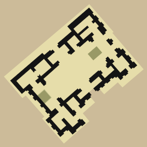
 Level VII Temple visualization
|
|
| Excavation |
| general info |
| Primarily Iraqi Antiquities Dept (Safar) and Lloyd, in the 1940s. |
|
|
| Phases |
|
Village settlement |
| time frame |
from circa 5400 BCE to circa 2900 BCE |
|
Mudbrick city, City state |
| time frame |
from circa 2900 BCE to circa 2050 BCE |
|
Declining settlement |
| time frame |
from circa 2050 BCE to circa 600 BCE |
|
|
| External Links |
| Wikimedia |
Links Index |
| Bing |
Map |
| OpenStreetMap |
Map |
| Google Maps |
Satellite - Satellite+Labels - Map - Terrain - - - Download KML |
|
| - - - |
|
Google
OSM
|
|
30.817023, 45.995855 === 30.817023 N, 45.995855 E === 30° 49' 1.3" N, 45° 59' 45.1" E |
| Web |
Eridu at Wikipedia |
|
| Related sites |
Eridu mound 2, Palace, circa 986 m (1078 yd) north
Eridu mound 5, circa 1.8 km (1989 yd) south-east
Eridu mound 3, circa 1.9 km (2114 yd) south-west
Eridu mound 6, circa 2.5 km (1.6 mi) south-west
Eridu mound 7, circa 3 km (1.9 mi) west
|
| Nearest sites |
Tell al-Ubaid, circa 17.6 km (10.9 mi) north
Ur, Uru.Unuki, Tell al-Muqayyar, circa 19.2 km (11.9 mi) north-east
Merejib, circa 18.9 km (11.8 mi) east
Tell es-Sakheri, circa 21.8 km (13.6 mi) north
Tell Abu Rasain, circa 22.3 km (13.9 mi) east
Ishan Abu Kumbaru, circa 32.5 km (20.2 mi) north-east
Tell al-Oueili, Tell Awayli, circa 48.4 km (30.1 mi) north
Kutalla, Tell Sifr, circa 53.2 km (33.1 mi) north
Larsa, Tell as-Senkereh, circa 53.7 km (33.4 mi) north
Kisiga, Kuara, Duru, Tell al-Lahm, circa 35.6 km (22.1 mi) east
Uruk, Unug, Warka, circa 65.9 km (40.9 mi) north-west
Ishan Rakiba, Ishan Ranya, circa 64 km (39.8 mi) north
Lagash, Tell al-Hiba, circa 77.3 km (48 mi) north-east
Tell et-Telliya, circa 65.7 km (40.8 mi) north-west
Umma, Tell Jokha, circa 95.1 km (59.1 mi) north
≫ more... |
|
| Tags |
Settlements, Looted sites |
| Database |
ID 8, created 15 Jun 2008, 02:58, Last changed 19 Nov 2024, 23:55 |
|